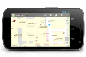
Google has now launched an indoor map feature in Australia which covers over 200 locations across New South Wale and Victoria. The new Google Indoor map allows the users to find their way inside airports, shopping centers, train stations and other large buildings using their mobile devices.
Presently, among the Airports, Google Indoor Map location is available in Adelaide Airport, Sydney Airport and Melbourne Airport and among the Transit stations; this service is available in Flinders street station, Southern Cross station, Parramatta Train station, North Sydney train station, Bondi junction, Central train station, Chatswood train station, Circular Quay, Wynyard and Town hall train station. The Google Indoor Maps is also available in various sports venues, Museums, Crown Melbourne Casino, Shopping Centers among other important places.
Australian Google Maps product manager Nabil Naghdy said the plan was to rapidly increase the number of floor plans, and to speed this up business owners could upload their own plans to Google.
“It’s like having an indoor directory in the palm of your hand helping you work out where you are, what floor you’re on and how to get to where you want to be,” he said.
The Google Indoor Maps technology is basically indoor directories which the user can carry around with them. This service does not require a GPS signal and instead relies on wireless networks. The indoor Google Map uses nearby Wi-Fi networks and mobile towers for operation. The maps will also automatically update themselves when you move up or down a level in a building with multiple floors.